Storms Return Tonight, Cooler Weekend Ahead
Source: KSNB Local4 Central Nebraska. Casualplayhub News adds summary, context, and editorial framing while linking back to the original report.
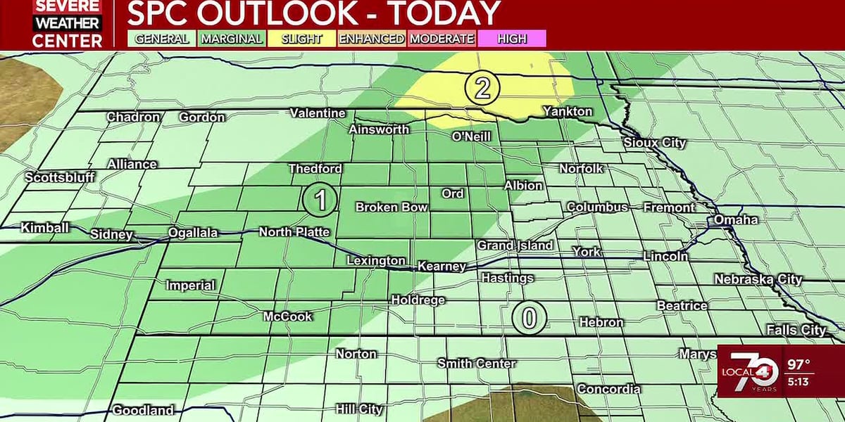
The Labor Day holiday brought intense heat across the region, with temperatures soaring into the mid-to-upper 90s. But the atmosphere is already shifting. Isolated thunderstorms have developed across southwestern portions of the area, and more storms are expected through the night into Tuesday. Some of these storms could turn strong, with a marginal risk of severe weather in place for tonight and again Tuesday afternoon, particularly across southeastern Nebraska.
Overnight, temperatures will drop into the mid-to-upper 60s across the western half of the region, while the eastern half sees lows in the low to mid 70s. Scattered showers and storms will continue through Tuesday morning, pushing eastward as the day progresses. By Tuesday afternoon, storms are expected to intensify over southeastern parts of the area, where another marginal risk has been issued. Highs will vary widely from northwest to southeast: the north and west may only reach the low to mid 80s, central Nebraska will see upper 80s to low 90s, and the southeast could hit the upper 90s. A heat advisory remains in effect for much of southeastern Nebraska through Tuesday afternoon.
More isolated to scattered thunderstorms are possible Tuesday night into Wednesday morning, mainly across southern and eastern areas. Wednesday morning, those showers and storms will clear out, leading to a cooler day with highs in the low to mid 80s. A slight warm-up follows Thursday, with highs in the upper 80s to low 90s west of the area and mid 80s to the east. Widespread 90s are expected Friday ahead of a cold front that will move through Friday night, bringing scattered showers and storms.
The weekend marks a dramatic shift. Temperatures will return to the 70s on Saturday afternoon, with additional shower and storm chances arriving Saturday night and continuing through Monday. The cooler pattern looks to persist into next week, with highs staying in the 70s for much of the period. This change is driven by a strong cold front that will sweep across the region, replacing the stagnant heat with a more fall-like air mass. Residents should prepare for a week of unsettled weather and much more comfortable temperatures after the recent heat wave.
Article commentary
This forecast highlights a classic late-summer transition in the central Plains, where the final days of meteorological summer often deliver a mix of lingering heat and the first significant cold fronts of autumn. The Labor Day heat wave, with highs in the mid-to-upper 90s, is typical for early September in Nebraska, but the arrival of a cold front by Friday night signals a pattern shift that could have broad implications. From a meteorological standpoint, the marginal risk for severe thunderstorms tonight and Tuesday is noteworthy. While marginal risks are the lowest on the severe weather scale, they still indicate that a few storms could produce damaging winds or hail. The heat and humidity present during the day will provide ample instability, and the approaching front will serve as a trigger. The strongest storms are likely to develop in southeastern Nebraska, where the heat advisory is in effect, because that region will have the highest surface temperatures and moisture content. The cooling trend beginning Wednesday is not dramatic initially, but the weekend drop into the 70s is significant. This type of temperature swing—from near 100°F on Friday to 70s by Saturday—is characteristic of a strong cold front. The National Weather Service's confidence in this pattern is high, given the consistency in model guidance. For agriculture, the sudden cool-down could be beneficial for crops that have been stressed by extreme heat, but the accompanying rain chances may also delay harvest activities. The extended forecast of 70s through much of next week suggests a sustained change in the weather regime. This could be the first sign that the jet stream is shifting southward, allowing cooler air masses to penetrate more frequently. For residents, this means a welcome break from the heat, but also a need to adjust outdoor plans. The increased rain chances, while beneficial for drought relief in some areas, could lead to localized flooding if storms train over the same areas. Overall, this forecast underscores the dynamic nature of early autumn weather. The transition from summer to fall is rarely smooth, and this week's rollercoaster of temperatures—from the 90s to the 70s—is a textbook example. The key takeaway is to stay weather-aware through Tuesday, as the thunderstorm threat is real, and to enjoy the cooler, more comfortable conditions that await by the weekend.